This walk explores the interesting and varied countryside to the west of the village. A number of routes have already been described to reach Surrendell House. The quickest is probably the bridleway Oarhedge Lane, which begins by the copse called Priors Corner. (See Walk Seven.)
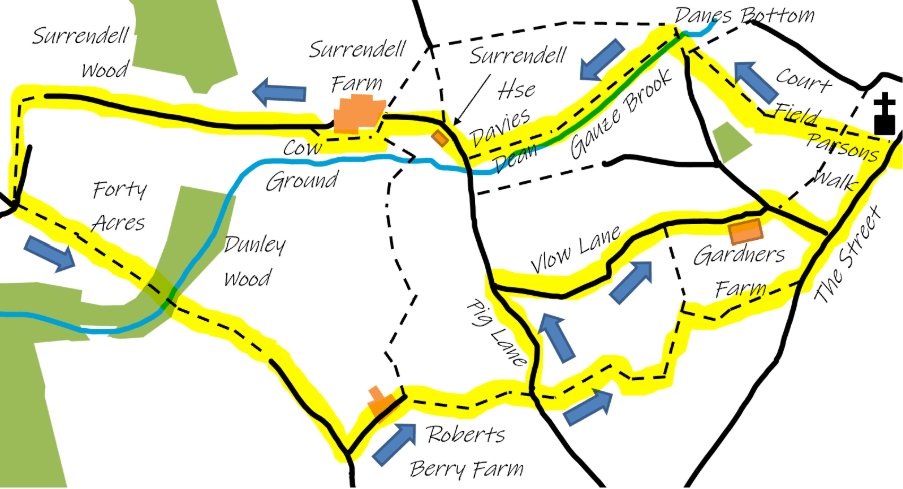
- From Surrendell House, follow the track to Surrendell Farm.
In the field on the left just after the grid observe an ancient Standing Stone under a hawthorn bush, known locally as “The Roman’s Grave”. Lore and legend maintain that it should never be ploughed up. This ceased to be a working farmhouse in the early 1960s when John and Dorothy Rawlins moved into Mays Farm in the village, having been there since just after the Second World War. John farmed the land at Surrendell for several years while the house stood empty. Since 1970 it has been occupied and restored. You can read a little of the history of Surrendell in June Badeni’s “Wiltshire Forefathers”. There was almost certainly a scattering of cottages there 150 years ago.
- Follow the wide track up to the gates of Surrendell Farm. Just before these gates there is a gate on your left that leads into a pasture Cow Ground. Go through it and walk along the farm house garden boundary keeping it on your right until you pass through another gate. There are some good views here down into the valley cut over the centuries by the Gauze Brook.
- Once through this gate head towards the metalled track and follow it to the end where it joins with a tarmac drive heading left. Follow the drive left past the converted barn and the large house (once was 2 farm cottages) on your left.
- Take the bridleway to the left. Along the edge of The Forty Acres and enter Dunley Wood about 400 yards ahead. The old cart track is clearly defined here with steep gradients.
Note the attractive old bridge as you cross the upper reaches of the Gauze Brook, which runs through the wood, though it’s usually dry for half the year. The wood is a haven for rabbits, foxes and badgers, as well as pheasants and many different kinds of birds. If you’re lucky you might see a roe deer.
- The track leaves the wood, becoming double-hedged and eventually joins the bridleway and access road to Roberts Berry Farm (formerly Clapcote) turn left towards Roberts Berry Farm following the bridleway. Fading daffodils and flowering cherries line the road in late April. Follow the bridleway to the farm, it goes between the farm buildings with the old farm house on your right.
- At the end of the track, you’ll see a modern dwelling on the right and a gate straight ahead, go through it into the field and look for another gate about 20 yards on the right which takes you into a small field. Head diagonally left to the visible stile at the top of this field and cross into the next field. From here the actual footpath goes diagonally left for about 200 yards to the gate (but it is often easier to walk around the edge of the field keeping the hedges on your right) that leads on to Pig Lane where you re-enter Hullavington Parish.
- You now have a choice. By road, you turn left and then right in about ¼ mile to follow the winding Vlow Lane for ¾ mile back to the village via Gardners Farm. Otherwise, you cross the road into Mr Hawker’s fields and by a series of zigzagging paths around Hullavington Field shown on the map but too tedious to describe, you should emerge from Water Furrows onto the Grittleton road. Turn left and it is ¼ mile back to the village.
